|
The Bangkok Floods – Reflections on the Waters
The lingering flood-waters on the Chao Phraya plain, especially in and around Bangkok, are a reminder of the vulnerability of all low-lying cities in Asia to heavy rainfall. While parts of the city have continued to function, though with difficulty, a number of outlying areas are still flooded and barely able to function more than a month after the beginning of the flood. This NTS Insight briefly examines the likely costs of the flood. It then reflects on what might have been had water depths been comparable to historical floods, and on the major technical and economic challenges that lie ahead with climate change expected to bring higher sea levels and possibly more frequent and even greater flooding.
By R.D. Hill.
 | The prolonged flooding in Bangkok and its vicinity in October–November 2011 raises the question: what could, and should, be done to address the risk of massive floods in the future.
Credit: Jennifer Villavolos / Navy Visual News Service. |
|
R.D. Hill is Honorary Professor in the School of Biological Sciences and the Department of History, The University of Hong Kong.
Contents:
Recommended Citation: Hill, R.D., 2011, ‘The Bangkok Floods – Reflections on the Waters’, NTS Insight, November, Singapore: RSIS Centre for Non-Traditional Security (NTS) Studies.
| |
Introduction
The media, in Thailand and internationally, has made much play of the word ‘unprecedented’ in speaking of the flooding in the Chao Phraya basin in October and November 2011. In fact, the flood, as a flood, has been by no means unprecedented. The water has risen to similar or higher levels in the past, most notably in 1942. In 1785 and 1819, the floods were probably at least double the recent heights. What has been unprecedented, however, are the number of people affected and the amount of economic damage done. The purpose of this NTS Insight is to reflect on the causes of this situation, to briefly assess what has been done to mitigate the impact of the flood and to critique the announced plan for a comprehensive water management scheme.
^ To the top
Flooding and the Hydrological System
Earth systems are chaotic and inherently unpredictable, at least on present knowledge. Tides are the exception; they tend to be regular and can thus be forecast with a fairly high degree of reliability. The movement of tectonic plates – which could trigger earthquakes and tsunamis, such as the Boxing Day 2004 event that so seriously affected parts of Thailand’s southern provinces – on the other hand, tend to be very difficult to predict. Flooding lies somewhere in between. Rainfall, especially its amount, timing and spatial extent, can be predicted only with difficulty; over more than a few days, the reliability of any prediction falls to low levels. Once rain has fallen, however, the height and timing of a flood are, in principle, relatively easy to compute – given timely reporting. In the case of the present flood, obtaining pertinent information has likely not been an issue, as maps prepared from satellite images have been readily available online.
The October–November 2011 Flood
In the current case, most of the rain seems to have fallen on the Chao Phraya plain. This is suggested by the fact that the water appears to have carried relatively small amounts of sediment. (Had the bulk of the rain fallen in the hilly areas, especially those used for agriculture, the sediment yield would have been much higher and the flood-waters more turbid, giving urban dwellers much more to clean up and giving rural lands a deeper top-dressing of silt than seems to have been the case).
Satellite images show that flooding has been most widespread in the back-swamp areas close to the edges of the Chao Phraya plain. However, there continues to be a major expanse of ponding to the north of Bangkok city – in Ayutthaya province and to the northeast. Although the area around Ayutthaya has been described as semi-aquatic as early as the 17th century, it is now home to a significant number of manufacturing facilities, seemingly installed without adequate forethought to the flood risk.
The flooding in the naturally low-lying province has been exacerbated by an extensive system of barriers in Bangkok city, some 70 km to the south. While these barriers have kept the central areas of Bangkok reasonably dry, they block the flow of flood-waters towards the sea.
The withdrawal of artesian water from the aquifers under Bangkok city, a human activity which has been going on for decades, is also aggravating the situation. Although the problem is now said to be under control, the effect has been to lower the level of the land on which the city is built. With land level at 0–1.5 m above sea level, the city is among the most vulnerable in Southeast Asia, especially at high tide when the sea forms a partial barrier, slowing the escape of flood-waters.
Comparisons to Earlier Floods
The present flood, with a level of about 1.5 m, is to be counted as only moderate in comparison to the flood of 1785 when the level is thought to have reached 4.3 m, and that of 1819 with an estimated level of 3.2 m. It is roughly comparable to the 1942 flood which had a level of 1.5 m and a dwell-time of two months. An early wet-season flood in May 1986 reached the same level but drained quickly as the rainfall was localised. Significant flooding also took place in 1975, 1980, 1982, 1983 and 1995, each leading to improvements in the city’s defences.
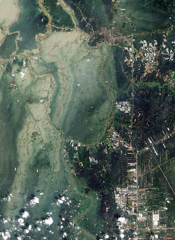
The scale of the flooding in Ayutthaya and Pathum Thani provinces can be seen in this satellite image taken on 23 October 2011.
Credit: Nasa Earth Observatory.
The number of people affected by the latest flood is, however, substantially greater than in 1990. According to official figures, the population of the city and its vicinity, an area of 7,762 sq km, was about 8.6 million in 1990, representing some 10.2 per cent of the national total. By 2010, the number had risen to 12.4 million, around 18.5 per cent of the total population. Clearly the drift to the city has markedly increased people’s vulnerability to flooding and its consequences.
^ To the top
Counting the Cost
The Impacts on Agriculture
The Chao Phraya plain is the source of the major portion of the country’s rice and vegetable crops despite the continuing spread of urban land uses and the consequent effects on agricultural production. Such expansion has clearly had major effects upon the hydraulic regime of hitherto rural areas. It is not just that those areas have become ‘waterproofed’ by various structures, leading to reductions in the absorption of water by the soil and the retention of water by rice-field bunds, but also that development for urban uses usually involves the import of spoil dumped into former fields to raise the land level for buildings. This practice means that the remaining areas have to deal with increased run-off from the urban areas, characteristically resulting in greater depths of flooding and increased dwell-times.
The effects of flooding on rice and vegetables are similar, though, because the mature rice plant stands taller than most common vegetables except maize, rice is less vulnerable to damage and death than vegetables. In both cases, complete immersion results in death within 3–4 days. Most of the premium rice varieties grown on the Chao Phraya plain are of medium stature and are thus less vulnerable than the high-yielding dwarf varieties grown in many other parts of Southeast Asia. Some rice varieties, low-yielding ones, have the ability to elongate during floods but these are sown only where flooding is deep and predictably so.
A further cause of loss is heavy rain, especially if accompanied by wind. Such rain and wind may beat down the grain panicles, making them harder to harvest. This probably occurs where immersion has not been complete. In the case of the present flood, the timing could hardly have been worse, for the crop was mostly approaching maturity.
Losses have yet to be fully estimated but it has been suggested that up to 10 per cent of the world’s rice crop has been lost. This will result in a price rise globally since Thailand is a major exporter of premium quality rice. It may also push some consumers to switch to less expensive varieties such as are produced in southern Vietnam.
The Impacts on Manufacturing, Commerce and Health
Bangkok and its surrounding region accounts for about 41 per cent of Thailand’s gross domestic product (GDP) and losses cannot be other than very substantial, not least because Ayutthaya and Pathum Thani have already been largely inundated for weeks. Honda’s factory in Ayutthaya has been closed since 8 October. Many others have also had to close, including Western Digital, whose factory supplies a significant proportion of the world’s computer hard drives, as well as 10 Toshiba factories producing a range of electronic goods. All are located in what should have been recognised as a flood-prone area.
One estimate, from the Jardine Lloyd Thompson group, puts the cost of rehabilitating the flooded areas at USD30 billion, while Moody’s Investors Service projects economic losses of USD6.5 billion. Economic losses include the costs of temporary protection and clean-up, the loss of wages and the reduction of local business activities. The tourist industry also stands to incur significant losses, though these may be offset by profits gained from wealthy urban dwellers moving temporarily to other places such as Chiang Mai and the resorts of the southern provinces. To these economic losses may be added the tragic loss of life, which reached over 500 early in November.
Fortunately, the potential risk of epidemic water-borne disease has not yet been realised, though with city sewerage systems flooded and people exposed to contaminated water on a daily basis, this is a little surprising. It would seem that most are aware of the risks and act accordingly, unlike in nearby Cambodia, also affected by flooding, where an outbreak of cholera has already been reported.
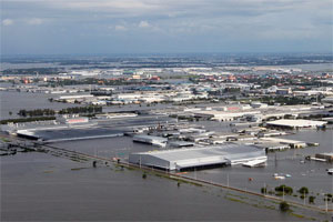
Seen here is the Rojana Industrial Park in Ayutthaya province in October 2011. Flood-waters have shut down many factories, with serious impacts on Thailand’s economy.
Credit: Robert J. Maurer / US Marine Corps.
The Overall Economic Impact
With water still covering much of the area, estimates of total costs, both in lost production and in rehabilitation, must be no more than educated guesswork. Moody’s estimates that the rate of Thailand’s GDP growth for 2011 will shrink to about 2.8 per cent compared with 7.8 per cent in 2010. Bank economists are estimating that the annual growth rate will fall to 2.6–2.9 per cent.
Exports of rice are projected to fall from a monthly average of about 1 million tons to about half that figure. Thailand's Bank of Agriculture and Agricultural Cooperatives has predicted that roughly 5 million tonnes of unmilled rice will be lost to flooding, a decline of about 20 per cent from the original projection for this year's harvest. However, this loss, while significant, will have less serious of an impact than previously, when rice exports used to be a major contributor to the nation’s GDP and its foreign exchange earnings. Today, only about 12 per cent of Thailand’s GDP is derived from agriculture and other primary economic activities.
The losses associated with manufacturing are more serious, as the sector now contributes about 45 per cent to the country’s GDP. Factory shutdowns are a matter of considerable importance, and not just locally. The production from Thailand’s factories is vital to supply chains elsewhere, notably in Japan.
^ To the top
Dealing with Flood Risks
Though those who have been affected by the flood may not think so, the country seems to have gotten off relatively lightly. Very roughly, and taking the 1785 flood as a point of comparison, water depths could have been about three times greater with a longer dwell-time. This would have been a total catastrophe, with economic losses at the very least comparable to the recent tsunami in Japan, though the loss of life would probably have been lower given that the onset of the flood was much slower than that of the tsunami.
Should the 1785 flood then form the basis for planning, when it could be centuries before there is again a flood of such magnitude? Or would planning to cope with a one- to two-metre flood be sufficient? The question is not trivial as Thailand’s Energy Minister Pichai Naripthaphan has said that the government expects to spend just over USD25 billion on a comprehensive water management scheme to protect the country against future flood disasters. It would be useful then to assess various solutions from a technical as well as economic standpoint.
Drains, Dykes and Dams
One temptation may be to extend the existing dykes and drains. Extending drains is not a bad idea though it would mean reversing the decades-long process of filling in the country’s canals in order to build roads.
Dykes, however, bring the risk of serious damage to surrounding areas in the event of leaks, breaks or breaches. Thus, where a difference of just a few centimetres in land level can make a huge difference to the extent of the area flooded, it is desirable to let nature take its course and allow natural sedimentation to take place; in all plains, floods bring larger or smaller quantities of sediment, building up the level of the land millimetre by millimetre. The example of the Hong River of northern Vietnam is instructive here. In places, the bed of that river is as much as 10 m above the level of the surrounding countryside.
When dykes fail, the effect could be catastrophic. In rural areas, the traditional adaptation strategy was to build dwellings on stilts and to keep a boat at hand for use when needed. Along riverbanks, the alternative was to build houses on a firmly moored floating platform of bamboos that could rise and fall with the water. (A few such still survive along the Chao Phraya). In the modern era, modern incarnations of these traditional means should be considered.
What about the notion of constructing massive dykes along the coast and along the Chao Phraya? Constructing coastal dykes would not present too much of a difficulty. Technically, the methods are well-known and long applied, in the Netherlands, for example. More importantly, the land to build such structures is at hand for there is relatively little urban development along the northern coast of the Gulf of Thailand.

The Thai military and volunteers work to repair a leak in a dyke in Bangkok, 31 October 2011.
Credit: Voice of America.
In the urban areas of Greater Bangkok, however, the problem of land acquisition to build large dykes would be extremely difficult to solve, perhaps even insurmountable. The alternative, building structures along the river while retaining the present building lines, would have the effect of narrowing the channel yet further and this would lead to even greater ponding effects upstream than now exist.
Whether in rural or urban areas, dyking would have to be backed by massive pumping capacity, much larger than required in the Netherlands. The reason is that not only is the annual rainfall in Thailand much greater, rainfall events are also much more severe. Intensities exceeding 100 mm per day are not uncommon. Further, intensities of more than 100 mm per hour are not unknown, though fortunately they rarely last more than a few hours.
Constructing dams exclusively for flood control purposes does not quite make economic sense. However, if combined with irrigation and power generation, this solution may be financially viable. The problem for the Chao Phraya catchment area is that there are probably no sites left that can be economically developed. The Electricity Generating Authority of Thailand certainly thinks so, since for several decades it has been sponsoring construction in Laos rather than Thailand itself. In any case, the management of multi-purpose dams is inherently difficult since the demands of water for electricity generation, for storage for irrigation and for flood control are to some degree contradictory.
Natural Processes
One way of reducing flood peaks is to keep water on the land. Where the land is under forest, the slowing of run-off occurs naturally. The soil itself, the soil litter and the vegetation absorb water, with some of it being returned to the atmosphere through transpiration. As much as 40 per cent of the rain that falls on forest areas may never reach streams. In the Chao Phraya catchment area, however, most of the forest has long gone and will never be replaced. Wet rice-fields are only as partial substitute. Although reasonably effective, most water-retaining mud bunds are no more than about 20 cm high, and with heavy rainfall, they are readily overtopped.
Effective control of soil erosion on sloping land is usually taken as essential in all water management schemes, not merely to reduce the loss of soil and the nutrients it contains, but also to reduce sedimentation behind dams and the cost of sediment removal in urban areas. In the Thai case, however, as with similar plains in the region, there is a need to consider the fact that lowland sedimentation is not keeping pace with sea-level rise. A sedimentation rate of 1–2 mm per year results in a rise in land surface of 10–20 cm per century, well below current projected rates of sea-level rise. On the face of it, therefore, it seems desirable to increase the rates of erosion from the uplands. However, such a strategy could result in coarse sediments coming to overlie good agricultural lands, which would lead to a decrease, or even abandonment, of agricultural production in the affected areas. The plain adjoining the Teesta River in north Bengal and the middle reaches of Vietnam’s Hong River are examples of what can ensue when deposits of coarse sediments create virtual deserts. This underlines the fact that erosion control in the uplands is not a tap to be turned off or on as required.
Urban Challenges
Urban areas present the greatest challenges in terms of water management. In Bangkok, the natural process of sedimentation and the resulting slow rise in land level is affected by two processes. One is the withdrawal of artesian water, which leads to the lowering of land levels. The other is the fact that post-flood cleaning results in the removal of sediment to dumps outside the city.
The city already has a number of protective structures, though these have been constructed somewhat haphazardly. However, none of these would be able to cope with a 4.3 m flood, and it is difficult to imagine just how a system of dykes that tall could be readily constructed. The city would need to be further divided into a series of compartments such that the failure of one would result in the flooding of that compartment alone and not the rest. This would basically mean a system along the lines of the Dutch polder system adapted to an urban environment combined with massive pumping capability. The cost would far exceed the proposed figure of just over USD25 billion for improving water management, and there would be enormous indirect costs such as even greater traffic congestion.
An alternative would be to accept the reality of floods and to work towards restructuring the city accordingly. Given the projected sea-level rise and for a given rainfall event, future flooding is likely to be both deeper than at present and the dwell-time longer. It would be relatively easy to build modern structures with a ground floor that can be easily evacuated, though the cost would perhaps be a little more than current building designs. The model here is Honolulu where new structures in low areas must be designed to cope with 3 m of water from a simultaneous occurrence of heavy rainfall and a storm surge along the coast. While Thais may experience some cultural antipathy towards this solution as they are not used to high-rise living, a reversal of the current process of urban sprawl could have important benefits. It would lead to more efficient use of land in urban areas, lower the unit cost of basic services, protect the rice lands which still supply an important market and help to reduce run-off.
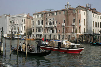
Could a public water transportation system on the pattern of present-day Venice be a solution for Bangkok in the face of rising sea levels and more extreme weather events?
Credit: Nino Barbieri.
More difficult to deal with is the problem of ensuring the continued availability of basic urban services during floods. Domestic water supply is a problem only when off-takes and treatment plants become submerged; thus, the solution is to pay attention to their future siting. The waterproofing of electricity distribution systems is more complicated. The current floods have resulted in a significant number of deaths by electrocution. Cutting off power supply is an option, but that has its own downside, especially for high-rise buildings. Another challenge is the prevention of the ingress of flood-waters into the sewerage system but that may be technically achievable.
Transportation tends to be a sector significantly affected by floods. One possible solution is to go back to the Bangkok or Ayutthaya of old when the predominant mode of transportation was by boat. This would imply the almost complete abandonment of private urban transportation in favour of public services, much on the pattern of present-day Venice. This could be criticised as an overly ambitious, even utopian, proposal. However, it is a measure of the potential adaptations that may have to be made in the face of higher sea levels and the likelihood of more extreme weather events. What is very probable is that within the next century, substantial sections of the city will not be slightly above sea level as at present, but a bit below it.
^ To the top
Final Reflections
Like many another lowland city, Bangkok will have to come to terms, and quickly, with the realities of nature. Most forecasts of climate change foresee more vigorous global circulation which is likely to bring heavier and more sustained rainfall, and deeper floods with longer dwell-times. At the same time, sea levels are projected to rise substantially with potentially severe consequences for low-lying urban areas such as Bangkok and its vicinity. Water management is, on its own, unlikely to be effective at coping with this situation.
The high concentration of people and especially of the means to create wealth in a single vulnerable city is a response to a free-wheeling economic system, one that for short-term gain has overlooked the obvious risk of concentrating a significant portion of its manufacturing sector in flood-vulnerable areas. Unlike in the US and Europe, where insurance companies and local governments play an important role by refusing to provide insurance or issue building permits in flood-prone areas, there are no such checks in Thailand.
To a degree, the economic injury that Thailand has experienced in recent weeks has been self-inflicted. True, the nation has long had in place a policy of encouraging manufacturing in its secondary cities, notably in Isan in the northeast, but the external economies of location in and around Bangkok have been too strong for that policy to have been fully successful.
For the future, the trick for the government, as always, will be to balance costs and benefits, both public and private. There will be a temptation to argue that the current flood is indeed unprecedented and that it will be a long time before a comparable event occurs. That would be a serious mistake. Natural systems are to a degree chaotic. A comparable flood could occur the next rainy season or the next or the one after that. Or it might not recur for a century. No one knows, or is able to predict with certainty. Should Thais and their foreign supporters then gamble with the future? The call is theirs to make.
^ To the top |
